Stanhope Arms - setting for How Not to Cry At Weddings

Marianna

Dedicated Member
Remember the Stanhope, where the wedding guests met the bus? It had been a hotel and pub, then it fell on hard times, probably because of the tiny population of the hamlet of Dunford Bridge, where it's located. It's at the end of the Trans-Pennine trail, where the multi-use path transitions to road-walking, so the Stanhope might have had a survivable level of pub and restaurant business only in spring, summer and autumn.

Now it's in the process of restoration and diversification in a way that might provide sufficient income during the trail-use season to survive the very lean winters. I've looked at the proposed plans on line, and it seems as though the ground floor of the the main building might be preserved, with any improvements limited to the hidden components, such as wiring and plumbing. The layout seems similar to the set used for the LOTSW episode. The first floor will consist of ensuite hotel rooms and the top floor will be the owners' home.

The diversification consists of a café, probably intended to attract people using the trail, camping pods, tent camping sites, and parking for caravans. The trail is marked as a bridle path, as well as for walking and cycling, so there's a small stable with three stalls and a tack room. The plans include showers and laundry facilities for the campers, too.

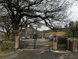
The hotel should be open well before my next trip to England in the autumn of 2024, so I'm thinking of spending a few days there. I'd like to walk to Winscar Reservoir, as well as a little way along the Trans Pennine Trail. New gates have been installed at the property entrance, so that's a sign of progress. I should have made a note of the photo source when I picked it up for my own information. Perhaps someone here will claim it. If so, please forgive my using it without acknowledgement.
 

Attachments

  • Stanhope - New gates.jpg
    Stanhope - New gates.jpg
    210.5 KB · Views: 13
I remember my day there well during filming for the last episode, I was told at the time of filming it was used as a training venue for upcoming local actors, and some were used as background artist, it was certainly a squash getting cast, crew and equipment all set up
 
I remember my day there well during filming for the last episode, I was told at the time of filming it was used as a training venue for upcoming local actors, and some were used as background artist, it was certainly a squash getting cast, crew and equipment all set up
That training center went bust pretty quickly. I've been trawling through back issues of newspapers for recent history, finding coverage mostly in the Sheffield and Barnsley papers.

So apparently that was one of the rare instances when interior scenes were filmed in the actual venue, rather than on a stage set? No wonder the background matched the online photos of the interior so well!
 
Glad to hear you are making plans to visit Holmfirth again, Marianna. As well as feeling good enough to want to walk Winscar Reservoir.

Imagine you have already visited Glenda & Barry's home before. Since you are so close to Hade Edge any plans to see it again? Have you been to the pub there since it got remodeled? The name of it escapes me at the moment but I think it was Summer Wine related.

edit:
The Bay Horse pub
Since remodeling, it's called the Boshaw Trout.

I haven't visited Hade Edge in person, only on Google Maps street view. I've never driven on the left, and I'm not about to try. At the age of nearly 80, my reflex to pull to the right in an emergency must be too firmly established to change without a lot of practice. There's a bus that goes out that way, but not much to see when I get there aside from Barry and Glenda's house.

On the other hand, the end of the Trans Pennine Trail at Dunford Bridge is fairly flat, since it's on a former railway bed. There used to be a station next to the Stanhope, just after the railway exited the 3-mile long Woodhead Tunnel. That brought quite a lot of business to the Stanhope; the line closure may have been instrumental in the hotel and pub's decline.
 
I echo RickAns sentiments, so glad you're planning a trip back over to Gods own country. Thanks for your extensive research, I'll certainly be planning a stay there in the foreseeable future.
I enjoy that kind of research. I'm a retired librarian. Got into the field because of an irresistible, general curiosity about history, now focused on the social history of northern England. Ended up working in a science research library, heavily focused on physics, about which I knew nothing and almost couldn't have cared less, but it paid much better than positions in public or university libraries, and financed as much travel as there was time for.
 
After over 3.5 decades of driving on the right I would be hesitant to try the left. Though the steering wheel being on the other side of the dashboard would be a remember of what side I should be on. Would hate to cause an international incident by falling into old habits and make a turn into the wrong lane at a crossroads!

When I finally make it over there I expect to do buses and a lot of walking. Would rent a bicycle but for the same above listed car reasons.

Wonder if they can turn some of the old rail lines into walk / run paths & bike trails? Could help bring in some business. Enjoy a nice pint after a few miles of exercise. I have done several "Rails for Trails" running meets at a brewery bar where I used to live. They would raise money to convert the rail paths into ones better suited for people to keep fit on. They can be nicely scenic and as you say the grade is fairly easy.
In addition to the Trans Pennine Trail, there's the Tissington Trail in Derbyshire. That's the only one I've experienced, and only for a very short distance. It runs close behind a hotel that used to be owned by HF Holidays, a not-for-profit company of which I'm a shareholder and with which I'm a frequent traveler. It was very easy walking, but it was necessary to be alert for bicycles coming up from behind. There's also one in the Lakes District from Keswick to Threlkeld. I've checked out the Keswick end of it because the rail station glass canopy is still in use, having been incorporated into the station hotel. Unfortunately, the light on it is never good enough to make an acceptable photo.

Because of all the railway closures, there must be many more.
 
Back
Top